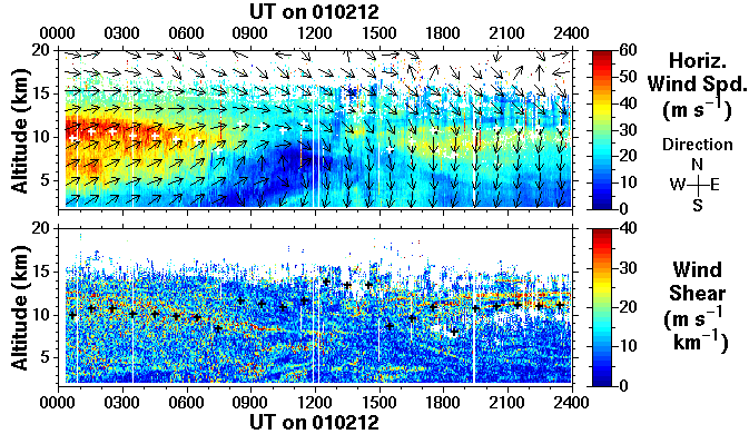
The horizontal wind vector is derived using the Doppler beam swinging technique, i.e. observations are made in a cyclic sequence of different beam pointing directions. The wind speed is indicated by the colour scale and the VECTOR direction by the arrows (which represent means over 1 hour in time and 2.1 km in altitude). Data are blanked where low signal-to-noise ratios make the Doppler shift evaluation unreliable. The vertical shear of the horizontal wind is derived from the horizontal wind vectors (over an altitude interval of 300 m) by:

- where:
- u - zonal velocity, i.e. component of horizontal wind towards East
(m s-1)
- v - meridional velocity, i.e. component of horizontal wind towards North (m s-1)
- z - altitude (m)
- v - meridional velocity, i.e. component of horizontal wind towards North (m s-1)
High values of wind shear are particularly useful for identifying frontal zones; there is typically a corresponding high shear zone above the jet in connection with such features. Frontal zones can also sometimes be characterised by an enhancement of radar return signal power owing to the increase of static stability. Note that a sharp change in wind direction, even without a change of speed, also constitutes a shear; the region of high shear around 6 km, between 1000 and 1200 UT, in the example above is characterised by a large rotation of the horizontal wind vector. This layer will be mentioned again in connection with the spectral width.

 THE NERC MST RADAR FACILITY AT ABERYSTWYTH